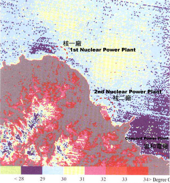
大地衛星紅光遙測
Satellite Telemetering for North Taiwan Land


台灣北部附近區域海面溫度,Landsat TM6,
Sea-surface Temperature near North Coast (Landsat TM6)

Yenliao104.jpg (71195 bytes)
                                                                    資料來源:國立中央大學太空遙測中心
                                                                 Resources:Space Telemetering Center ,National Central University

dot4.gif (381 bytes)據查大地衛星紅光遙測顯示,核一、核二廠進、出水口海域已全部白熱鹽化,全年平均溫度均在34~40度(℃)以上,其海、陸生態系元素「活綠因子」全遭破壞,以致生物植物化,也因核穢高溫污水和金屬化合物背離合理容忍度,致其海灣珊瑚礁及維生物種悉數根絕,更可怕海溫由內向外東西擴散,倘若不及時因應,西至澎湖列嶼,東至台東海溝將會無一倖免其害。註:(核一、核二海灣漲落潮序為西東)
dot4.gif (381 bytes)With the satellite infrared telemetering ,we found that the waters at the outlet of 1st Nuclear Power Plant and 2nd Nuclear Power Plant all have been incandescently salified. The average annual temperature is 34-40℃. Due to damage of both land and sea ecology ,the biology all have been plantlike. Besides high-temperature wastewater and metallic compounds are out of the reasonable tolerance ,so coral reef and microbe in the bay all have been killed. With the expansion of high-temperature sea water ,the Pescadores(West) and Taitung Trench (East) will be impacted as well provided that we fail to do something in due course.

prev.gif (1707 bytes)<P5> <回鹽寮反核> <至目錄區>next.gif (1760 bytes)